


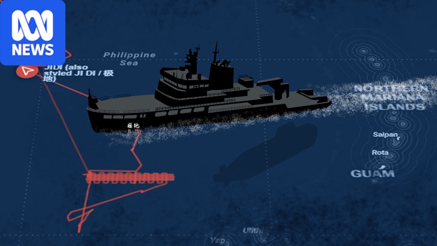
In the final days of May, a Chinese research vessel ventured 74 kilometres into Palau’s waters and reportedly spent 14 hours moving slowly through the island nation’s maritime zone.
With a bow built to push through a metre of Arctic sea ice, the 89-metre icebreaker, Ji Di, might have looked out of place in the warm waters of the North Pacific.
The Ji Di was designed to push through polar sea ice. (U.S. Coast Guard Courtesy Photo)
Exactly what it was doing remains unclear to Palau’s President Surangel Whipps Jr.
“Their research vessels come into our EEZ (Exclusive Economic Zone) uninvited and do whatever they want,” he said.
“What are they looking for, and what is the ultimate intention?“
Launched in 2024, the Ji Di was designed to carry out environmental monitoring and surveying to respond to climate change, according to Chinese state media.
Its fleet of unmanned drones and underwater vehicles can map the sea floor and collect data on everything from undersea minerals, ocean currents and marine ecosystems.
But security experts fear the vessel, and dozens of others like it, might also be gathering intelligence for a military purpose — one that could aid Beijing in the event of a future conflict over Taiwan.
The Ji Di travelled roughly 74 kilometres into Palau’s EEZ between May 30 and 31. (Micronesia Security Monitor)
Hidden agenda
The Ji Di’s incursion was not an isolated incident for Palau.
Similar incidents were reported in 2018, 2024 and 2025, while in 2023, a Chinese vessel allegedly operated near Palau’s fibre optic cable.
The most recent incursion, according to Mr Whipps, came in July, a day after China launched a ballistic missile from a submarine that flew over multiple Pacific islands.
The ABC was unable to independently confirm the incursion.
“They’re surveying over the top of our fibre optic cable and they have gear in the water, so for us it’s a security concern,” Mr Whipps said.
Surangel Whipps Jr said Chinese research vessels have become a security concern for his country. (Supplied)
Sixteen Chinese research vessels have been deployed into the north Pacific this year, according to the Pacific Centre of Island Security — a think tank that tracks vessels and geopolitical activity in the region.
Jennifer Parker, an adjunct professor of defence and security at the University of Western Australia, said while some vessels would be used for “pure science”, the scale and location of China’s activities also suggested they could be gathering intelligence to conduct submarine and anti-submarine warfare against the United States.
“If you look at where Hawaii and Guam are, where US subs are based, and how they would operate across the Western Pacific, you can see why waters around Palau are important,” she said.
In 2024, an investigation by the Center for Strategic and International Studies into 64 Chinese research vessels found 80 per cent demonstrated suspicious behaviour or had organisational links suggesting involvement in advancing Beijing’s geopolitical agenda.
The study said China had developed the largest fleet of civilian research vessels in the world, heavily concentrating its surveys in the South China Sea and western Pacific Ocean.
Science or spying?
The dual-use nature of research vessels can make their true purpose difficult to discern, because mapping the sea floor can serve both scientific and military objectives.
A 2025 study published in the journal Frontiers in Political Science noted that “unlike other countries, China doesn’t distinguish between ships operating for naval survey, scientific research, or commercial purposes”.
But director of the Pacific Centre for Island Security, Leland Bettis, said there were clues in the vessels’ patterns.
Leland Bettis says the patterns created by Chinese research vessels provide clues to their purpose. (ABC News: Kent Velesrubio)
Mr Bettis said the Ji Di was tracked in May following a pattern that suggested it was mapping the ocean floor near Guam along a corridor likely to be used by US submarines.
“It’s doing a lawnmower pattern, which is typical of oceanographic survey work,” he said.
“The fact it’s doing the lawn-mowing positioning directly off of Guam where US submarines are based underscores the potential for some of the dual use capabilities.”
Leland Bettis said the Ji Di’s “lawnmower” movement pattern is typical of oceanographic survey work. (Micronesia Security Monitor)
A recent Lowy Institute report into China’s military said two of the main priorities of the People’s Liberation Army was developing the forces needed to invade Taiwan and deterring or defeating a US intervention.
As a hub for military operations in the Pacific, Guam is home to multiple US nuclear submarines and would likely be used as a staging area if the US intervened in a Taiwan conflict.
Mr Bettis said Chinese research vessels could be trying to track the “signatures” of US submarines or even planting listening devices.
“Increasingly we’ve seen the use of drones and other submersibles that float around or [are] managed by an operator to collect information,” he said.
Guam is home to multiple nuclear submarines which operate in the Western Pacific. (Reuters)
Ms Parker, who is also a former Australian anti-submarine warfare officer, said understanding the sea floor was critical for operating and hunting submarines.
She said detailed mapping helped submarines navigate terrain like underwater mountains and trenches.
The shape and depth of the seabed, along with ocean temperature, also affects how sound travels through the water column.
Jennifer Parker says China aims to expand its submarine operations into the second island chain — a strategic line of Pacific islands stretching from Japan through Guam to Micronesia. (Reuters)
“The primary way you detect subs is through sound — passive by listening or active by putting sound in the water and getting it to bounce back,” she said.
Playing by its own rules
Marine scientific research in another country’s EEZ without permission is a breach of international law, said Ms Parker.
But Palau’s options to stop China entering its territorial waters are limited.
In a diplomatic complaint to China, Palau said the incursion showed a disregard for its sovereignty and the “rules-based order” nations are supposed to follow.
Ms Parker said China had been operating under its own rules in its efforts to map vast expanses of the Pacific and Indian Oceans.
Jennifer Parker said China frequently breaches international law while mapping the ocean floor. (ABC News: Callum Flinn)
“It is uncommon to see countries conducting survey operations in another country’s EEZ without permission, and the only country I can think of that does this at scale is China,” she said.
China meanwhile has defended the activities of its vessels in the Pacific, saying in July an alleged incursion near the Japanese island Okinawa was “legitimate, lawful and beyond reproach”.
The ABC reached out to the Chinese embassy for comment.
Ms Parker said as China continued to project power across the Indo-Pacific, research vessels would likely become a more common sight.
“China has been doing this more across the Pacific and Indian Ocean, including in places just north of Papua New Guinea, so I think we’ll see more of this,” she said.
